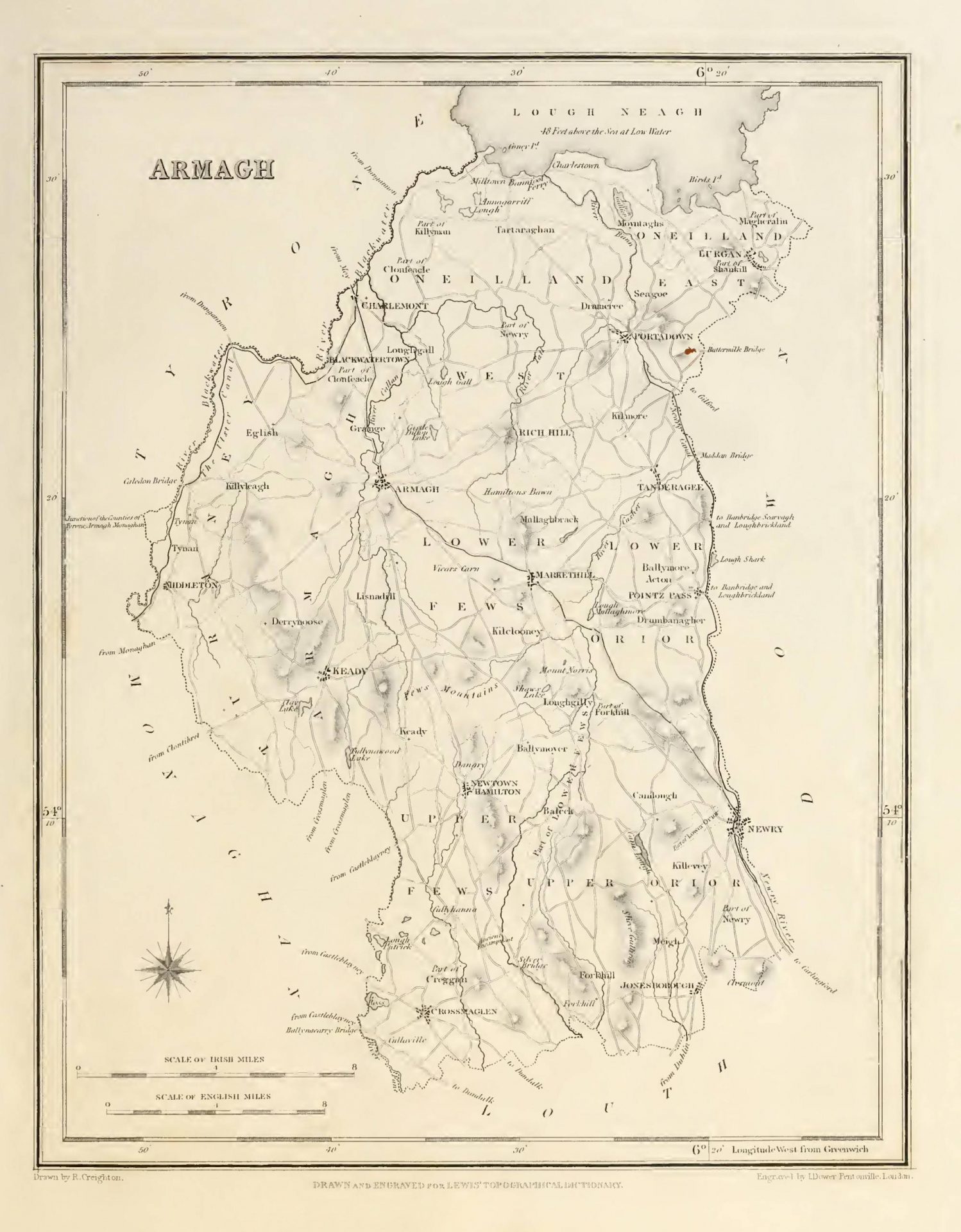

ARMAGH (County of), an inland county, in the province of Ulster, bounded on the north by Lough
Neath, on the east by the county of Down, on the south-east by that of Louth, on the south-west by Monaghan, and on the west and north-west by Tyrone. It is situated between 54° 3′ and 54° 31′ (N. Lat ), and between 6° 14′ and 6° 45′ (W. Lon.); and comprises 328,076 statute acres, of which 265,243 are arable land, 35,117 uncultivated, 8,996 plantation, 778 under towns and villages, and the remainder water. The population in 1831 was 220,134, and in 1841 it amounted to 232,393. This tract is supposed to have been part of that named by Ptolemy as the territories of the Vinderii and Voluntii; it afterwards constituted a portion of the district called Orgial, which also comprised the counties of Louth and Monaghan. The formation of this part of Ireland into a separate dominion is said to have taken place so early as the year 332, after the battle of Achaighleth-derg, in Fermoy, in which, as recorded by Tigernnch, abbot of Clonmacnois, who died in I068, Fergus Feagha, son of Froechair the Brave, the last of the Ultonian kings who resided in Eamania, was killed by the throe Collas, who then expelled the Ultonians from that part of the province to the south of Lough Neagh, and formed it into an independent state. To this state they gave the appellation of Orgial, afterwards corrupted into Oriel or Uriel, names by which Armagh was distinguished to the beginning of the seventeenth century.
The county was made shire ground, under its present name, in 1586, by the lord-deputy, Sir John Perrott,
who, not relying with confidence on the vigilance and care of Henry O’Nial and Sir Henry Bagnell, to whom
the government of Ulster had been entrusted, projected the division of the greater part of that province into seven counties, of which Armagh was one, taking its name from the chief town in it. For each of these
counties he appointed sheriffs, commissioners of the peace, coroners, and other officers. Previously to this
arrangement, the chief part of the property of the count) had centered in the family of the O’Nials, the
Mac Cahans, and the O’Hanlons. At the commencement of the seventeenth century, it was principally vested in those of Mac Henry, Acheson, O’Nial, Brownlow, and O’Hanlon, exclusively of the great territories settled on Moharty, which the Mac Cahans had forfeited in rebellion, and of a large tract of country called Oirther, afterwards Orior, a district in the southern part, which escheated to the crown by rebellion of a branch of the O’Hanlons. According to a project for planting, by James I., the whole of the arable and pasture land, amounting to 77,580 acres, was to be allotted in 61 proportions of three classes of 2000, 1500, and 1000 acres each, among the English and Scottish undertakers, the servitors, and the Irish natives. A portion was also assigned to the primate; another for glebes for the incumbents, of whom there was to be one for each proportion; another for the four corporate towns of Armagh, Mountnorris, Charlemont, and Tanderagee; and a fourth for a free grammar school. The native Irish were to be distributed among a few of the several proportions, with the exception of the swordsmen, who were to migrate into waste lands in Connaught and Munster. The project, which was but partially effected, was not acted upon until 1609, when a royal commission was issued to inquire into the king’s title to the escheated and forfeited lands in Ulster, with a view to the plantation there. Inquisitions were consequently held, the return of which for Armagh, made in August of the name year, states that the county was then divided into the five baronies of Armaghe, Toaghriny, Orier, Fuighes, and Onylane or O’Nealane, and enumerates with great particularity the names and tenures of the proprietors. In 1618, a second commission was issued to Captain Pynnar and others, to ascertain how far the settlers located there in the intervening period had fulfilled the terms of their agreement. It is somewhat remarkable that, although the inquisition names five baronies, three only are noticed in Pynnar’s survey; those of Armaghe and Toaghriny being omitted, probably because they contained no forfeited property. The number of the proportions specified in the survey are but 93, eleven of which, situated in O’Neylan, were in the hands of English undertakers; five, in the Fuighes, were in those of Scottish undertakers; and seven in Orier had been allotted to servitors and natives. The number of tenants and men capable of bearing arms in the two first proportions amounted to 319 of the former,
and 679 of the latter ; the number in Orier is not given.
The county is partly in the diocese of Dromore, but chiefly in that of Armagh. For civil purposes it is
now divided into the baronies of Armagh, Turaney, O’Neilland East, O’Neilland West, Upper Fews, Lower
Fews, Upper Orior, and Lower Orior. It contains the city and borough of Armagh; part of the borough, sea-port, and market-town of Newry, which is noticed more particularly under the head of the county of Down; the market and post towns of Lurgan, Portadown, Tanderagee, Market-hill, and Newtown-Hamilton; the disfranchised borough of Charlemont; the post-towns or post-villages of Richhill, Keady, Blackwatertown, Loughgall, Tynan, Forkhill, and Flurry-Bridge ; and the market-towns of Middleton and Crossmoglen. Prior to the Union it sent six members to the Irish parliament, two for the county at large and two for each of the boroughs of Armagh and Charlemont ; at present its representation consists of three members in the Imperial parliament, two for the county at large and one for the borough of Armagh. The election takes place at Armagh. The county is in the north-east circuit: the assizes are held at Armagh, where the county courthouse and gaol are situated; and quarter-sessions at Armagh, Lurgan, Market-hill, and Ballybott, the three last of which have each a court-house and bridewell. The local government is vested in a lieutenant, vice-lieutenant, 14 deputy-lieutenants, and 50 other magistrates; besides whom there are the usual county officers, including three coroners. There are 25 constabulary police stations, having in the whole a force of a county inspector, 5 sub-inspectors, 6 head constables, 23 constables, and 116 sub-constables ; maintained equally by grand jury presentments and by government. The amount of grand jury presentments, for 1844, was £24,227. The public charitable institutions are, a district lunatic asylum, the county infirmary, and a fever hospital, at Armagh; fever hospitals at Middleton and Tanderagee ; and dispensaries at Crossmaglen, Forkhill, Market-hill, Jonesborough, Keady, Blackwatertown, Seagoe, Loughgall, Richhill, Lurgan, Newtown- Hamilton, Poyntz-Pass, Tynan, Portadown, Tanderagee, and Ballybott, supported by equal grand jury presentments and private subscriptions. There are also dispensaries
at Tanderagee, Portadown, and Tullyhappy, built and supported by the Earl and Countess of Mandeville; and the fever hospital at Middleton is supported by the trustees of Bishop Sterne’s munificent bequest. In the military arrangements this county is within the Belfast district, of which Armagh is the head-quarters, where there are an ordnance-depot and an infantry barrack constructed to accommodate 12 officers, 174 men, and 5 horses: at Charlemont is a fort, with on artillery barrack for 5 officers, 151 men, and 79 horses, to which is attached an hospital for 22 patients.
The northern verge of the county, near Lough Neagh, the north-western adjoining Tyrone, and the neighbourhoods of Armagh, Market-hill, and Tanderagee, have a level surface , the remainder is hilly, rising in the southern parts into mountains of considerable elevation. The highest of these is Slieve Gullion, 1893 feet above the level of the sea; it is about seven miles from the southern border, and sinks on the east into the Fathom hills, which skirt the Newry water. One of the finest and most extensive prospects in Ulster is obtained from its summit, which commands the bay of Dundalk; and the bold and picturesque features of mountain scenery in the county are confined to this immediate vicinity, including the Doobrin mountains and the neighbourhood of Forkhill. Westward to the Fews the country exhibits a chain of abrupt hills, the greater part of which can never be reduced to a state of profitable cultivation: the Fews mountains are a subordinate range, lying in a direction from south-east to north-west. The fertility of the more level districts towards the eastern, northern, and north-western confines is very remarkable, especially as displayed in the views from Richhill, the numerous demesnes being sufficiently wooded to ornament the
whole country, and the surface generally varied by pleasing undulations. From the shores of Lough Neagh,
however, extend considerable tracts of low, marshy, and boggy land. The other lakes are few and small :
that of Camlough, romantically situated on the northern verge of Slicve Gullion, is the largest. Lough Clay, in the western part of the county, which gives rise to one of the branches of the Callan river, is the next in size; but none of the lakes, except Lough Neagh, would be noticed for extent or beauty if situated in some of the neighbouring counties. A chain of small lakes occupying the south-western boundary of the county is valuable from the supply of water afforded by them to the mills in their neighbourhood. Coney Island, near the southern shore of Lough Neagh, and between the mouths of the Blackwater and Bann rivers, is the only island in the county; it is uninhabited. The climate is more genial than that of most of the other counties in Ulster, as is evinced by the greater forwardness of the harvests: this advantage has been attributed to the nature of the soil and subsoil, the gentle undulation of the surface, the general absence of moor or marshy land, and the protection by mountains from the cooling breezes of the sea.
The soil is usually very fertile, especially in the northern part, the surface of which is a rich brown loam,
tolerably deep, on a substratum of clay or gravel. There is an abundance of limestone in the vicinity of Armagh, and in Kilmore and other places; and there are quarries near Lough Neagh, but the stone lies so deep, and they are subject to such a flow of water, that they are of little practical use. Towards Charlemont there is much bog, which yields red ashes, and is easily reclaimable; the substratum of this is a rich limestone. The eastern part of the county consists of a light friable soil. In the south the country is almost entirely rocky and barren: huge rocks of granite appear on the surface promiscuously mixed with blocks of limestone, as if thrown together by some convulsion of nature. All the limestone tracts make good tillage and meadow ground: the natural meadow found on the banks of the rivers, and formed of a very deep brown loam, yields great crops without manure. The hilly district is generally of a deep retentive soil on a gravelly but not calcareous substratum: a decayed freestone gravel, highly tinged with ferruginous ore, is partially found here: the subsoil is sometimes clay-slate. In these parts heath is peculiarly vigorous, except where the judicious application of lime has compelled it to give place to a more productive
vegetation. Except near Newtown-Hamilton, there is but little bog among the hills. The valleys that lie be-
tween them have a rich and loamy soil, which yields much grain, and does not abound in aquatic plants,
although the poa fluitant grows luxuriantly. The general inequality of surface which pervades the county affords great facilities for drainage.
In consequence of the dense population the farms are generally small, and much land is tilled with the
spade. Wheat is a very common crop in the baronies of Armagh, the O’Neillands, and Turaney; the main
crops in the other baronies are oats, flax, and potatoes. In the smaller farms potatoes constitute the first and second crops, sometimes even a third , and afterwards flax occupies a portion of the potato plot, and barley the remainder, if the soil be dry and fine, but if otherwise, crops of oats are taken in succession. The treatment of the wheat crop consists of one harrowing and one ploughing, to level the potato furrows ; if two crops of potatoes have preceded, a small quantity of ashes is scattered over the surface. The seed most in use is the red Lammas wheat, and the quantity sown is about three bushels to the acre. Potato oats are commonly sown on the best lands ; black oats, and sometimes white oats, on land manured with lime, in the mountainous districts: the last species, when sown on mountain land not previously
manured and drained, will degenerate into a black grain in two or three seasons. Flax is invariably sown on
potato ground, the plot being tilled with the spade, but not rolled : Dutch seed is sown ou heavy soils, American on light soils. The seed is not saved, and therefore the plant is pulled just before it changes colour, from an opinion that when thus prepared it makes finer yarn. More seed was sown in 1835 than was ever before known, in consequence of the increased demand from the spinners in England and Ireland. The pasturage is abundant and nutritious ; and though there are no extensive dairies, cows are kept by all the small farmers of the rich northern districts, whence much butter is sent to the Belfast market : a considerable quantity of butter, generally made up in small firkins, is also sent to Armagh and Newry for exportation. The state of agriculture in modern times has very much improved; gentlemen and large farmers have introduced all the improved agricultural implements, with the practice of drainage,
irrigation, and rotation crops. Mangel-wurzel, turnips, clover, and all other green crops arc now generally cultivated even upon the smallest farms, particularly around Market-hill, Tanderagee, Banagher, and other places, where the greatest encouragement is given by Lords Gosford, Mandeville, and Charlemont, and by Col. Close and other resident gentlemen, who have established farming societies and expend large sums annually in premiums.
The Durham, Hereford, North Devon, Leicester, Ayrshire, and other breeds of cattle have been introduced, and by judicious crosses a very superior stock has been raised ; some farmers on good soils have also brought over the Alderney breed, which thrives remarkably well. In some of the mountain districts, however, the old long-horned breed of the country is still preferred, and a cross between it and the old Leicester appears to suit both soil and climate, as they grow to a large size, give great quantities of milk, and fatten rapidly. The breed of sheep and horses has also been greatly improved; the former kind of stock is chiefly in the possession of gentlemen and large farmers. The horses used in farming art- mostly a light active kind ; the best hunters and saddle horses are brought hither by dealers from other
counties. Many herds of young cattle are reared an the Fews mountains, which are the only part of the county where grass-farms are extensive. Goats are numerous, and are allowed to graze at liberty in the mountainous districts. Hogs are fattened in great numbers, the gentry prefer the Chinese breed, but the Berkshire is preferred by the country people, as being equally prolific and more profitable. The number of farms of more than one acre each is 23,855, on which there was in 1841 a stock of 12,449 horses and mules, 35,235 horned cattle, 5,042 sheep, 28,432 pigs, and 150,598 head of poultry , the whole of the estimated value of £382,000. Lime and dung are the general manures; the former is usually mixed with clay for the culture of potatoes, and is also applied to grass-lands as a surface dressing preparatory to tillage, sometimes even three years before the sod is broken, as being deemed more effective than manuring the broken ground; the average quantity of lime laid on an acre is from 30 to 40 barrels. Thorn hedges well kept are the common fences in the more fertile districts, and, with scattered timber-trees and numerous orchards, give them a rich woody appearance. In the mountainous district, too, similar fences are
rising in every direction. Many parts of the county, particularly in the barony of Armagh, are decorated
with both old and new timber . and in comparison with neighbouring districts it has a well-wooded appearance; but there are no extensive woodlands, although near Armagh is a large public nursery of forest-trees. There axe 406 acres of oak plantation in the county, 19 ash, 10 elm, 17 beech, 212 fir, 5549 mixed timber, and 2783 fruit; besides 406,075 detached trees, equivalent to 2,538 acres : total, 11,534 acres.
The geological features of the county are various and interesting. The mountain of Slieve Gullion, in its
south-eastern extremity, is an offset of the granite district of Down, and is remarkable for the varieties of
which it is composed. It is in the form of a truncated cone, and presents on some sides mural precipices several hundred feet in height, from which it acquires an appearance of greater elevation than it really attains: the summit is flat, and on it is a lake of considerable extent. The granite of this mountain, particularly that procured near the summit, is frequently used for millstones, being extremely hard and fine-grained, and composed of quartz, felspar, mica, and hornblende. This, indeed, is in Armagh the common composition of this primitive rock, the felspar being grey, and the mica black. Sometimes the hornblende is absent, in which case the rock is found to be a pure granite; and in other instances it graduates into a beautiful sienite composed of flesh-coloured felspar and hornblende. Flesh
coloured veins of quartz are also found to variegate the granite, in a beautiful manner, in several places. On
the south, towards Jonesborough, the sienite succeeds to the granite, and afterwards passes into porphyry, which is succeeded by silicious slate. The Newry mountains and the Fathom hills are granite. Around Camlough mica-slate is found in vast beds. Westward the granite district of Slieve Gullion extends to the hill above Larkinmill, on the western declivity of which the granite basis is covered by almost vertical strata, composed first of an aggregation of quartz and mica with steatite, which in the distance of about a quarter of a mile is occasionally interstratificd with greenish grey clay-slate, of which the strata still further west are wholly composed. Several slate-quarries have been opened here, and partially worked, but none with spirit or skill; the principal are at Dorcy, Newtown-Hamilton, Cregan-Duff, and in the vicinity of Crossmaglen. Further distant this clay-slate becomes greywacke-slate, by being interstratified with greywacke. In the neighbourhood of Market-hill the strata comprise hornblende- slate and greenstone-porphyry. Sandstone is also connected with this district; there is a quarry of remarkably fine freestone at Grange; and on the surface of the southern confines is seen the intermixture of grit and limestone rocks already noticed.
Trap rocks, forming a hard stone varying in hue between dark green and blue, here called whin, are found
in various places in huge blocks and boulders or long narrow stones. The substratum of the eastern portion of the county varies between a silicious schistus and an argillaceous deposit, forming a greywacke district, which extends across to the western confines of the county. The west and middle of the county are limestone, which is generally white, except in the vicinity of the city of Armagh, where it assumes a red tinge, exhibiting that colour more distinctly as it approaches the town, improving also in quality, and increasing in the varieties of its shades. The minerals, as connected with metallurgy, are so few as scarcely to deserve notice, lead only excepted, a mine of which was worked in the vicinity of Ready, on a property held by the Earl of Farnham, under Dublin College ; but after much expenditure the operations were discontinued in consequence of the loss incurred, which, however, has been attributed to the want of skilful or honest superintendence. Lead-ore has also been found near Market-hill, in several places
near Newtown-Hamilton, on the demesne of Hallymoyer, in Slieve Cross, near Forkhill, near Hockley, and in the parish of Middleton. Some indications of iron, imperfect lead, regulus of manganese, and antimony, have been met with in a few spots. The other mineral substances are potters’-clay and a variety of ochres. Various kinds of timber, particularly oak, pine, and yew, have been raised out of the bogs . petrified wood in
found on the shores of Lough Neagh ; and fern, spleenwort, and mosses have been discovered in the heart of slaty stones.
The woollen trade flourished extensively in this county until interrupted by the legislative measures enacted by William III., and cloth of every description was manufactured. The linen manufacture is now pursued in all its branches, the finest goods being produced in the northern parts. The extent of the manufacture cannot easily be ascertained, because much comes in from the outskirts of the neighbouring counties, though the excess thus arising is probably counterbalanced by the goods sent out of Armagh to “the markets in the adjoining counties. At the commencement of the present century, the value of its produce annually was estimated at £300,000, and at present it exceeds £500,000. Large capitals are employed by bleachers, who purchase linen and bleach it on their own account; the principal
district is on the river Callan, at Keady. Considerable sums are also laid out in the purchase of yarn, which
it given to the weaver to manufacture. Woollen goods are now made solely for home consumption, and in only small quantities. Manufactories for the necessaries of life in greatest demand, such as candles, leather, soap, and beer, are numerous; and there are mills for dressing flax and spinning linen-yarn, and many large flourmills.
The two principal rivers are, the Blackwater and the Bann, which chiefly flow along the north-western and
north-eastern boundaries of the county, respectively. The former, which rises in Tyrone, joins the county
near Caledon, at the junction of the counties of Monaghan, Armagh, and Tyrone, from which it flows in a
wide and beautiful river, discharging itself into the western side of Lough Neagh. The Bann enters the
county from the county of Down ; passing Gilford in the west of Down, it joins the Newry canal, and flowing
thence, falls into the southern part of Lough Neagh, at the Bann- foot ferry. The Newry water, or river, also
enters the county from Down, and running a short distance in a narrow valley along the boundary of the
county, below Newry enters the county of Louth in its course to the bay of Carlingford. The Lallan has two
sources in the centre of the county; one in Lough Aughnagurgan, in the parish of Armaghbreagh ; the
other in Mullaghbrack. It runs northward ; and being joined by the Butterwater and Whitewater streams from the Fews mountains, and winding by the western base of the eminence on which is the city of Armagh, it falls into the Blackwater near Moy. The Cusheir rises near Baleek ; it flows in a north-east and north course to the village of Clare, thence by the towns of Market-hill and Tanderagee. and falls into the Bann at its junction with the Newry canal. The Tall water rises between the villages of Richhill and Hamilton’s-Bawn; passes through the parishes of Kilmore and Loughgall, and, changing due west towards Charlemont, joins the Callan near its union with the Blackwater. The Camlough, flowing from the lake of the same name, discharges itself into the Newry water. This last-named river, during its short course of five miles, supplies numerous bleach-works, and corn, flour, and flax mills: its falls are so rapid that the tail race of the higher mill forms the head water of the next lower. The Newtown- Hamilton river is joined by the Tara, and flows into Dundalk bay, into which also the Flurry or Fleury, and the Fane,
empty themselves. The total number of main and branch streams is eighteen, and the combined lengths
of all are 165 miles. The mouths of those which flow into Lough Neagh have a fine kind of salmon-trout,
frequently 30lb. in weight : the common trout is abundant and large, as are also pike, eels, bream, and roach.
An inland navigation along the border of the counties of Armagh and Down, from a short distance south of
Newry to Lough Neagh, by the aid of the Bann and the Newry water, was the first line of canal executed in
Ireland. Commencing at the tideway at Fathom, it proceeds northward to Newry, and in this part of the
line admits vessels drawing nine or ten feet of water, having at each cud a sea lock. From Newry to the
point where the Bann is navigable, a distance of fifteen miles, is a canal for barges of from 40 to 60 tons,
chiefly fed from Lough Bricklaud und Lough Shark, in the county of Down. An extension from Fathom southwards, and other improvements, are in progress. The river Bann, from its junction with the canal to Lough Neagh, a distance of eleven miles and a half, completes the navigation, opening a communication with Belfast by the Lagan navigation, and with the Tyrone collieries by the Coal-Island or Blackwater navigation. The chief trade on this canal arises from the import of bleaching materials, flax-seed, iron, timber, coal, and foreign produce, from Newry; and from the export of agricultural produce, yarn, linen, fire-bricks, pottery, &c. The canal from Lough Erne to Lough Neagh enters this county near Tynan, and passes by Caledon, Blackwatertown, and Charlemont to its junction with the river Blackwater above Venter’s bridge, and finally with Lough Neagh. The railways are noticed under the heads of the towns where the termini are placed. The roads are generally well laid out, and many of them of late
have been much improved.
Among the relics of antiquity are the remains of the fortress of Eamania, near Armagh, once the royal seat
of the kings of Ulster. The Danes’ Cast is an extensive line of fortification in the south-eastern part of the
county, and stretching into the county of Down. The tumulus said to mark the burial-place of “Nial of the
hundred battles ‘ is still visible on the banks of the Callan. The Vicar’s Cairn, or Cairn-na-Managhan, is
situated near the city of Armagh; Cairn Bann is in Orior barony, near Newry. A tumulus in Killevy
parish contains an artificial cavern. Two ancient brazen weapons have been dug up in a bog near Carrick, where a battle is said to have been fought in 941. Spears, also, battle-axes, skeyns, swords, the golden torques, and collars, rings, amulets, medals of gold, and various ornaments of silver, jet, and amber, have been found in different places, and are mostly preserved. Near Hamilton’s Bawn, in 1816, was found the entire skeleton of an elk, the head and horns of which were placed in the hall of the Infirmary at Armagh . and in the same year the body of a trooper was discovered in a bog near Charlemont, the armour of which appeared to be of the reign of Elizabeth. The only religious houses, besides those of the city of Armagh, of which any memorial has been handed down to us, were, Clonfeacle. Killevey or Kilsleve, Kilmore, Stradhailloyse, and Tahellan. The most remarkable military remains are, Tyrone’s ditches near
Poyntz-Pass, Navan fort, the castles of Criff-Keirn and Argonell, the castle in the pass of Moyrath, and Castle Roe.
The peasantry are in possession of superior comforts in their habitations as well as in food and clothing, which cannot be attributed solely to the linen manufacture, as their neighbours of the same trade in the adjoining counties of Cavan and Monaghan are far behind them in this respect. The county has within its limits sufficient fuel for domestic consumption; but coal is imported from England by the Newry canal, and from the county of Tyrone by the Blackwater. In no other county do the working classes consume so much animal food. The general diffusion of the population is neither the result of a pre-determined plan, nor of mere accident: it arises from the nature of the linen manufacture, which does not require those employed in it to be collected into overgrown cities, or congregated in crowded factories. Engaged alternately at their loom and in their farm, the people derive both health and recreation the alternation. Green lawns, clear streams, pare springs, and the open atmosphere, are necessary for bleaching: hence it is that so many eminent bleachers reside in the country, and hence also the towns are small, and every hill and valley abounds with rural and comfortable habitations.
In the mountainous districts are several springs slightly impregnated with sulphur and iron. The borders of the bogs sometimes also exhibit ferruginous oozings, and one of these, in the Fews mountains, is said
to be useful in scrofulous complaints. The same effect was formerly attributed to the waters of Lough Neagh, in the north-western limits of this county; and Boate states, in addition to this, that the temperature of the sand at the bottom of the bay in which this sanative quality is perceived, alternates frequently between cold and warmth. A petrifying quality such as that said to exist in some parts of Lough Neagh, has been discovered at Rosebrook, near Armagh, the mansion-house of which was built, in a great measure, of petrifactions raised from a small lake there. Petrified branches of hawthorn have been found near the city of and fossil remains of several animals have been in the limestone rocks in the same vicinity.
Petrifactions of the muscle, oyster, and leech, together with dendrites, belemnites, and madreporites, are also found; and in the mountain streams are pure quartz crystals, of which a valuable specimen has been found near Keady.
Leave a reply