Castle, Culleen More, Co. Westmeath
Co. Westmeath |
Tower Houses
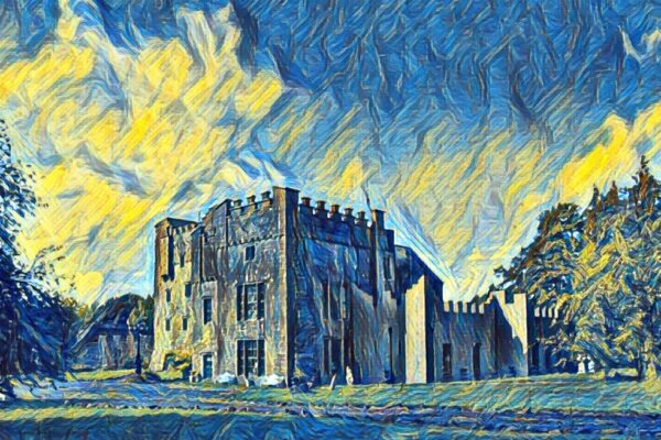
Located on the southeast side of a farmyard at Culleenmore House, the ruins of this rectangular tower house tell a story stretching back to the 17th century and beyond.
Historical records from the Down Survey map of Mullingar parish show the castle standing on the north bank of a stream, with the 1641 terrier listing William Pettit and Andrew Tuite, described as 'Irish Papists', as the landowners. The structure appears on Ordnance Survey maps from 1837, where it's shown adjoining a barn, and by the 1913 edition it's marked as 'Castle (in Ruins)', indicating its deterioration over the centuries.
The tower house measures approximately 9.8 metres northwest to southeast and 7.8 metres northeast to southwest, with walls about 1.5 metres thick and standing roughly 5 metres high. Built from rubble stone, the structure retains several fascinating features despite its ruined state. The ground floor boasts a partially intact barrel vault in its southeast half, whilst the southeast wall contains a large fireplace complete with a wall oven on the northeast side. The northwest corner has collapsed entirely, and sometime after 1700, the northwest wall was incorporated into a stone barn that still runs alongside the ruins.
Archaeological evidence suggests this was once part of a larger complex. A possible bawn wall extends southwest from the southern angle, creating a rectangular enclosure that would have provided additional defence and space for the castle's inhabitants. This wall features a small pointed doorway dating to the 15th or 16th century, hinting at the site's medieval origins. Earthworks visible in the surrounding fields to the northeast and southeast suggest further structures or defensive features once existed here. The site's historical importance is recognised through its preservation order, granted in 1987 under the National Monuments Acts.
Visitor Notes
Added by