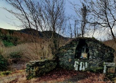
Church, Cloghore, Carrickboy, Co. Donegal
In the countryside of County Donegal lies a peculiar mystery: the supposed site of Tetunny Church, marked on Ordnance Survey maps from 1902 but curiously absent from the physical landscape.
Church, Cloghore, Carrickboy, Co. Donegal
When surveyors plotted this location over a century ago, they recorded a church that seems never to have existed where they claimed. Archaeological surveys have found no trace of foundations, stones, or any remnant that might suggest a religious building once stood here.
The real story likely lies about 100 metres south, where Tetunny Burial Ground sits within a distinctive circular enclosure. This shape hints at something far older than a simple graveyard; circular enclosures often mark early Christian sites in Ireland, places where small monastic communities or churches stood from the 6th century onwards. Though no visible ruins remain today, the burial ground’s form suggests this was indeed an ecclesiastical site of some antiquity. Supporting this theory, local tradition speaks of a holy well that once existed to the southeast, now lost to time but recorded in folklore collections as Tetunny holy well.
The confusion over the church’s location reveals how oral history and mapmaking sometimes diverge. The Ordnance Survey cartographers of 1902, working from local information and place names, may have simply misplotted the church site, or perhaps they were recording a folk memory of where locals believed it stood. What remains clear is that this corner of Donegal held religious significance for centuries, even if the exact spot where prayers were once offered has been forgotten. The Archaeological Survey of County Donegal, compiled in 1983, officially notes this discrepancy, acknowledging that while the maps show one thing, the landscape tells quite another story.