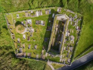
The cashel at Lisduff, known in Irish as Lios Dubh, the dark fort, is a bivallate cashel, meaning a stone ringfort enclosed by two circuits of boundary rather than the more common single ring. The scale of it is considerable: the interior measures roughly 51 metres east to west and 43 metres north to south, with the full extent of the outer works pushing the total to around 64 by 60 metres. A cashel differs from an earthen ringfort in that its principal enclosing element is a dry-stone wall rather than a bank and ditch, and this one's inner wall, built from horizontally laid stones averaging about 60 centimetres long and 30 centimetres high, still stands to between 1.4 and 2 metres on its outer face in the better-preserved sections. The outer face is deliberately battered, angled slightly inward as it rises, a technique that gives the structure both structural stability and a quietly imposing profile.
The site appears on the first edition Ordnance Survey six-inch map of 1842, hachured to indicate an earthwork or enclosure, and was named Lisduff on the 25-inch plan of 1897 and again on the Cassini edition of 1906. Robinson's map of the Burren, produced in 1977, gives the Irish form, Lios Dubh. Despite that long cartographic record, the site was classified only as an enclosure in the Record of Monuments and Places in 1996, a designation that somewhat underplays what is actually there. The hazel-covered inner wall is largely well-built and substantial, though sections to the south-south-west and west are badly overgrown and the inner face has collapsed inward. Later drystone field walling has been added to the outer face in places, particularly from the north-north-west around to the north, and on the inner face at the south-east, showing that the structure continued to serve practical agricultural purposes long after its original function was forgotten. The entrance passage, roughly 2.6 metres wide, is placed at the east-north-east and lined with large rough stones across the berm, the flat strip of ground between the inner wall and the outer bank. Inside, large cairns of stone abut the inner wall-face to the west and north-west; these may represent the tumbled remains of an internal terrace, or simply the accumulated debris of centuries of slow collapse.
The interior is now mostly grassed over, with two broadleaf trees growing near the centre, and the outer bank, which carries its own drystone wall on top in most places, is covered in scattered stone. A spread of stone roughly 3.5 metres across sits about 7 metres outside the bank to the west, its purpose unclear. The entrance passage, though lined with substantial stones, is uneven and disturbed where it passes through the main wall, suggesting that whatever once made this threshold more formal has long since been removed or has simply given way.